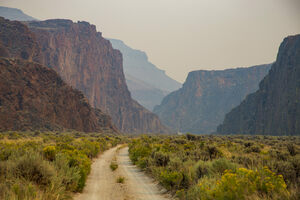
High Rock Canyon Wilderness in Gerlach, Nevada

First described by explorer John Fremont in 1843, High Rock Canyon soon became an important route in the westward migration to Oregon Territory and the California goldfields.
Crossing the nearby Black Rock Desert was a difficult and dangerous part of the journey. The flat, alkaline dry lake bed offered little water for travelers. Arriving at the canyonlands was a relief, as water and food were more abundant. Although navigating the canyons was not without difficulties.
To enter the canyon, early settlers had to lower their wagons using a rope to the canyon floor. Several were destroyed in the process.
Those early visitors were in awe when they laid eyes on the canyon. Vertical rock walls tower 300 feet over the trail below. Several settlers marked the occasion by carving their names into the rocks. Some wrote their names using axle grease, which is still visible today.
This mountainous area was formed by ancient lava flows. The canyons were created as a result of tectonic activity and erosion. Several other gorges form the area, such as Yellow Rock and Mahogany Creek Canyons. The latter being so narrow that at one point visitors can touch both sides with arms outstretched.
Due to a high water table, there are several springs in the area. It’s not uncommon to see flowers in bloom during the late summer. Wildlife is abundant in the area. Prior to the arrival of settlers, this region was an important site for Native Americans.
To protect the cultural, historic, and natural significance of the area, Congress designated the surrounding land as wilderness in 2000. This limits motorized travel, but the primary trails are still open to vehicles.
Because the area is so remote, visitors can experience the night sky as brilliantly as the early settlers did. The lack of light pollution led nearby Massacre Rim to be named as an International Dark Sky Sanctuary in 2019.


